
Leaderfoot Bridge
At first, we drove by thinking, "why is there an aqueduct here?", but discovered this is a defunct 19th century railroad bridge. It makes a striking sight from the modern overpass only a few hundred feet away.
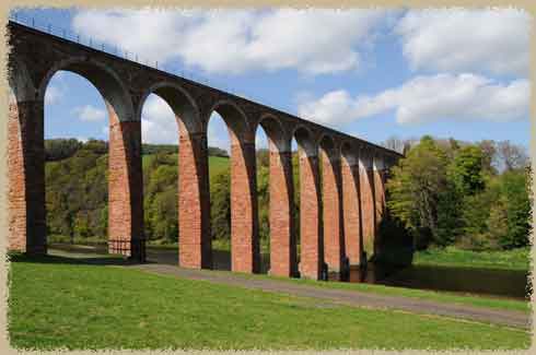
while it looks like a roman aqueduct, it is a railroad viaduct
It spans the Tweed River near Melrose and was opened as a railroad bridge in 1863. It was used until the 1940s for passenger trains.
 At first glance, it looks like brick, but the nineteen' arches are made of red sandstone (and there are obvious repairs of brick and concrete).
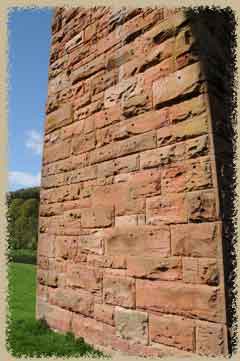
. The arches are rough sandstone, and we puzzled for a moment over the weird holes in each of the stones, until we realized that they were for hooks or clamps to lift the blocks into place. It actually looks like they've been gouged or bashed to give them texture, too.
As we walked up along the pathway we followed signs to see a roman amphitheatre (which was just faint outline in a field, to be honest) and met a number of people walking on the shoreline of the River Tweed. One couple told us that there was a way to climb up to the top of the viaduct, but it was gated and chained off -- while it was probably possible to get on to the bridge, it was obvious that no one wanted us to climb it!
Nearby is another late 19th century bridge (the Drygrange Bridge), now a pedestrian pathway with a small car park near one end. You can see the modern overpass in the background. It offers a nice view of the viaduct, if you aren't trying to stare directly into the sun. Drygrange dates from the 1780s, and it is thought that this primary river crossing was built on the site of a much earlier Roman bridge. The main roman roads converge on this area, at least on my map, but we didn't see any obvious signs of an earlier bridge.
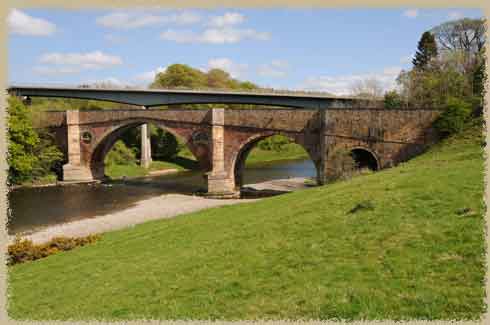
nearby Drygrange Bridge